Why did we do it?
The Carnarvon Basin was explored extensively in the 1980’s and 1990’s when 3D surveys were expensive and tended to be relatively small and prospect specific. This data is now open file and provides reasonably extensive coverage. However, not only have processing techniques advanced in the intervening years, but these surveys often comprise small, partly overlapping data sets that vary widely in quality, character and vintage – which is likely to leave you wondering what might be hidden in the gaps.
So what’s an UltracubeTM?
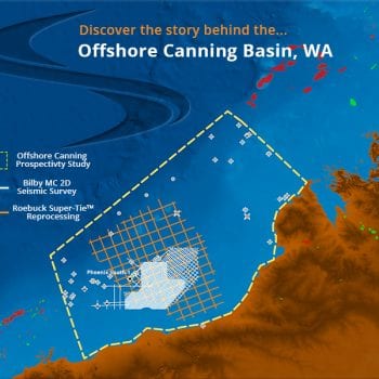
Searcher, in conjunction with Fugro, went back to the field tapes and reprocessed ~23,000km2 of vintage 3D data to make one consistent survey, making the Carnarvon Ultracube Australia’s largest ever non-exclusive 3D PSTM reprocessing project.
And now there’s more – 14,700 km2 of PSDM data more! Searcher has partnered with DownUnder GeoSolutions to increase our coverage in the Carnarvon Basin with the addition of the Monodon Ultracube, plus ~2,000km 2D reprocessed data covering 2015 acreage.
Will it help me explore?
The resulting contiguous volumes provides a valuable tool for evaluating the remaining potential of this highly prospective basin and includes coverage to current open acreage and bid round areas. The improved imaging of the Ultracube data has provided clear explanation for some dry holes, highlighted leads that were previously lost in the gap between surveys and revealed deeper plays that were just not apparent on the original data. It just might change your opinion about an area…..
- Carnarvon Basin, Western Australia
- ~37,700 km2 of reprocessed data
- Includes coverage of the 2015 bid round areas and open acreage.
- Available Now!
If you want to discover, you need to search…it’s as simple as that.

Click here to explore Searcher’s global multi-client data library.


