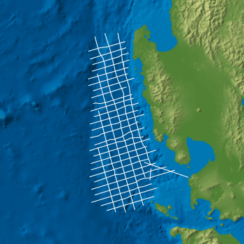
The Pala-Sulu Non-Exclusive 2D Seismic Survey consists of ~6,200 km of newly acquired long offset 2D seismic data over the Palawan, Mindoro-Cuyo, Sulu Sea and Sandakan basins called the Pala-Sulu Seismic Survey.
The regional seismic survey provide the first consistent link between the basins to create a uniform stratigraphic framework.
The survey has been designed to better define the tectonic framework of the Philippines’ most important petroleum basins and to improve the imaging of the lower sedimentary sections and basement. Previously unrecognised in the East Palawan Basin, modern seismic data has revealed a 10 km depocentre which was designated the Mialara Sub-Basin. Regional evaluation indicates potential for multiple play types, large structures and several proven petroleum systems in Western Philippines to be present in the Eastern region.
The survey utilises state of the art acquisition and processing to ensure the resulting dataset is of the highest quality. A full suite of additional deliverables has been produced during processing to allow for further studies such as basin modelling, AVO and inversion.
For further information on the Pala-Sulu Non-Exclusive 2D Seismic Survey, please contact us directly.
Project parameters
| Project Size | ~6,200 km |
|---|---|
| Acquisition Details | Seabird Aquila Explorer |
| Acquisition Parameters | Sample Rate: 2 ms Record Length: 12 sec Streamer Length: 7 km |
| Key Processing Parameters | SRME Kirchhoff PSTM |
| Deliverables | Full Angle AGC Migration Final Angle Stacks AVO Products PSTM Gathers Navigation Data RMS Stacking Velocities Processing Report Interpretation Report |
Project partners
Department of Energy Philippines & SeaBird Exploration


